Advancements in technology have revolutionized wildlife conservation efforts, enabling the deployment of over 10,000 camera traps globally, capturing millions of wildlife images annually, and leveraging advanced algorithms to optimize trap placement and AI-driven analysis to detect poaching threats. Acoustic sensors track endangered species with precision, while drones equipped with advanced cameras monitor wildlife populations and habitats. Real-time monitoring systems and genetic analysis provide valuable insights, informing swift responses to emerging threats. As technology continues to evolve, it's clear that its impact on wildlife conservation is only just beginning to unfold.
Monitoring Wildlife With Camera Traps
Approximately 10,000 camera traps are currently deployed across the globe, capturing millions of images of wildlife annually, revolutionizing the way scientists monitor and study animal populations. This innovative approach has transformed the field of wildlife conservation, providing valuable insights into the behavior, habitat, and population dynamics of various species. Effective camera placement is essential in capturing high-quality images, and researchers are now utilizing advanced algorithms to identify ideal locations for camera trap deployment.
Proper trap maintenance is also vital to guarantee the longevity and effectiveness of these devices. Regular cleaning and upkeep of camera traps prevent malfunction and data loss, allowing researchers to collect consistent and reliable data. Additionally, advancements in camera trap technology have enabled the development of more durable and weather-resistant devices, capable of withstanding harsh environmental conditions.
The data collected from camera traps is invaluable in informing conservation efforts, enabling scientists to identify areas of high conservation value, track population trends, and monitor the impact of human activities on wildlife populations. By leveraging camera trap technology, conservationists can develop targeted strategies to protect endangered species and preserve biodiversity. As camera trap technology continues to evolve, it is likely to play an increasingly important role in the fight against species extinction and the preservation of our planet's precious wildlife heritage.
AI in Anti-Poaching Efforts
As camera traps provide valuable insights into wildlife populations, artificial intelligence is being harnessed to combat the devastating impact of poaching on endangered species. AI-powered systems can analyze camera trap images, identifying potential poaching threats and alerting rangers in real-time. This proactive approach enables rapid response times, increasing the chances of catching poachers in the act.
However, as AI becomes more integral to anti-poaching efforts, concerns around AI ethics and data privacy arise. It's essential that conservationists prioritize responsible AI adoption, ensuring that systems are designed with transparency, accountability, and fairness in mind. This includes implementing robust data privacy measures to protect sensitive information, such as camera trap locations and species habitats.
Predicting Habitat Loss With GIS
Geographic Information Systems (GIS) have revolutionized the field of wildlife conservation by enabling researchers to predict habitat loss with unprecedented accuracy. By analyzing spatial data, conservationists can identify patterns of deforestation and habitat destruction, allowing them to pinpoint areas that require immediate attention. This technology has become essential in predicting future habitat loss, enabling proactive measures to be taken to protect endangered species.
Mapping Habitat Destruction
Moreover, Geographic Information Systems (GIS) allows conservationists to pinpoint areas vulnerable to habitat destruction, accurately predicting where human activities will likely encroach upon wildlife habitats. By analyzing satellite imagery and spatial data, they can identify patterns of land fragmentation, where human migration and urban sprawl lead to the breakup of contiguous habitats. Ecosystem modeling helps Conservationists understand how these fragmented habitats affect local species' populations and overall ecosystem resilience. Climate modeling is also integrated to predict how shifting weather patterns will impact habitats and species distribution. In addition, GIS enables the tracking of resource extraction activities, such as mining or logging, which can have devastating effects on ecosystems. By mapping these threats, conservationists can prioritize areas for protection and develop targeted strategies to mitigate habitat destruction. This proactive approach enables more effective conservation efforts, ultimately protecting biodiversity and preserving ecosystem integrity.
Spatial Data Analysis
By integrating spatial data analysis with GIS, conservationists can pinpoint areas prone to habitat loss, enabling them to forecast how human activities will encroach upon wildlife habitats. This integration allows for the identification of spatial autocorrelation patterns, which reveal how adjacent areas affect each other. By analyzing these patterns, conservationists can predict the likelihood of habitat loss and fragmentation. Landscape fragmentation, a major threat to biodiversity, can be mitigated by identifying areas most susceptible to fragmentation and prioritizing conservation efforts accordingly.
The spatial analysis of habitat loss also enables conservationists to identify areas of high conservation value. By mapping habitat loss and fragmentation patterns, conservationists can develop targeted strategies to protect critical habitats and corridors. This data-driven approach empowers conservationists to make informed decisions, allocating resources more effectively and maximizing the impact of conservation efforts. By leveraging spatial data analysis and GIS, conservationists can stay one step ahead of habitat loss, working to preserve the delicate balance of ecosystems and protect the world's most vulnerable species.
Predicting Deforestation Patterns
Through advanced spatial modeling and machine learning algorithms, conservationists can accurately predict deforestation patterns, identifying areas most vulnerable to habitat loss and enabling proactive conservation strategies. By analyzing satellite imagery and GIS data, researchers can pinpoint areas of high deforestation risk, allowing for targeted conservation efforts. Land use modeling and forest fragmentation analysis enable the identification of areas prone to habitat destruction, while machine learning algorithms can detect subtle changes in land use patterns. This critical approach enables conservationists to develop targeted strategies, such as reforestation programs and habitat restoration, to mitigate the impact of deforestation. By leveraging these technologies, conservationists can stay one step ahead of habitat loss, protecting critical ecosystems and preserving biodiversity. As the fight against deforestation continues, the integration of advanced spatial modeling and machine learning algorithms will be essential in predicting and preventing habitat loss, ensuring a safer future for our planet's precious wildlife.
Acoustic Sensors in Conservation
Acoustic sensors, strategically placed in wildlife habitats, are revolutionizing conservation efforts by detecting and tracking endangered species with unprecedented precision. By capturing and analyzing sound patterns, these sensors provide valuable insights into ecosystem health. For instance, the unique vocalizations of species like the African elephant or the Sumatran rhino can be identified and monitored, enabling conservationists to track their movements and populations. This information is vital in developing effective conservation strategies and mitigating human-wildlife conflict.
Moreover, acoustic sensors can detect subtle changes in sound patterns, indicating early warnings of ecosystem disruptions. For example, the sudden absence of bird songs or the altered calls of a specific species can signal habitat degradation or the presence of invasive species. By detecting these changes, conservationists can respond promptly to mitigate the impact of these disturbances on ecosystem health.
The data collected from acoustic sensors can also inform conservation efforts by identifying areas of high conservation value. By pinpointing regions with high species diversity or unique sound patterns, conservationists can prioritize their efforts and allocate resources more effectively. As the use of acoustic sensors continues to expand, it is likely to play an increasingly important role in the fight against species extinction and ecosystem degradation.
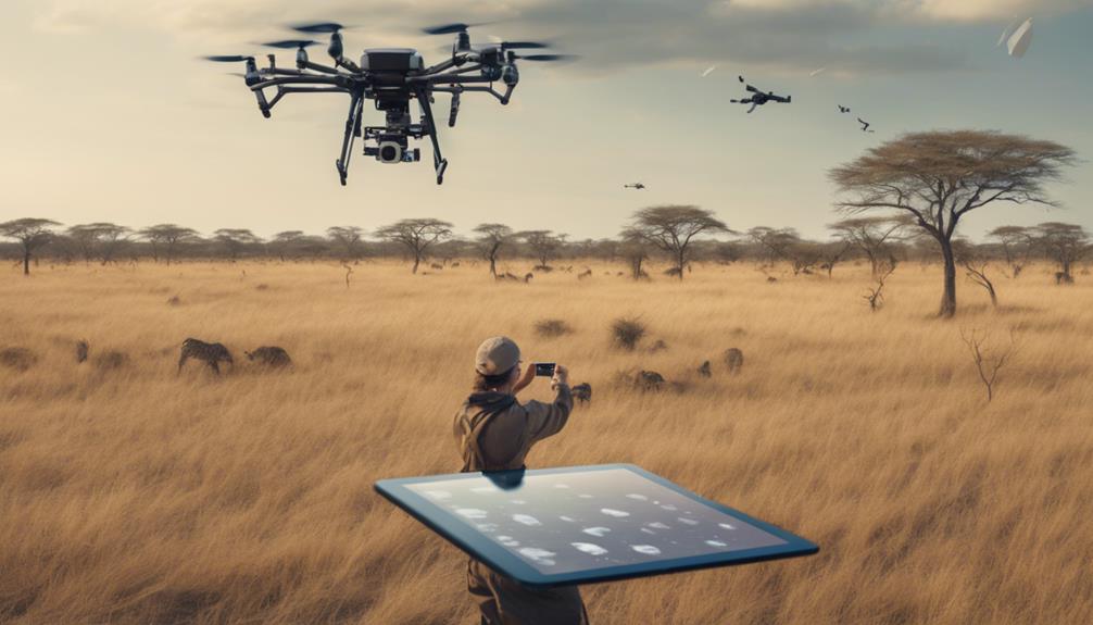
Drones in Wildlife Surveillance
They're taking wildlife surveillance to new heights – literally. Drones equipped with advanced cameras and sensors are being deployed to monitor wildlife populations and habitats in real-time, providing conservationists with crucial insights. By analyzing aerial imagery, researchers can track species migration patterns, detect poaching activity, and identify areas of habitat destruction.
Real-time Monitoring Systems
Around 90% of wildlife surveillance efforts now rely on real-time monitoring systems, which have revolutionized the way conservationists track and protect endangered species. Drones equipped with sensors and cameras are deployed to collect crucial data on wildlife populations, habitats, and ecosystems. This data is then transmitted in real-time to conservationists, enabling them to respond promptly to threats and make data-driven decisions.
| Feature | Description |
|---|---|
| Data Encryption | Guarantees secure transmission of sensitive data, protecting it from unauthorized access. |
| Sensor Calibration | Ensures accuracy and consistency of data collected by sensors, reducing errors and inconsistencies. |
| Real-time Analytics | Facilitates conservationists to analyze data in real-time, facilitating swift responses to emerging threats. |
Real-time monitoring systems have greatly improved the efficiency and effectiveness of wildlife conservation efforts. By leveraging advanced technologies, conservationists can now respond rapidly to threats, such as poaching and habitat destruction, and make more informed decisions to protect endangered species. As technology continues to evolve, the potential for real-time monitoring systems to drive positive change in wildlife conservation is immense.
Aerial Imagery Analysis
Advanced aerial imagery analysis, powered by drone technology, has become a game-changer in wildlife surveillance, allowing conservationists to gather high-resolution visual data on species populations and habitats with unprecedented accuracy. By leveraging high-resolution cameras and advanced sensors, drones can capture detailed images of wildlife habitats, enabling researchers to identify and track species populations, monitor habitat health, and detect signs of human-wildlife conflict. Effective flight planning is essential in achieving high-quality imagery, as it enables drones to capture images at the best-suited time and angle, ensuring maximum image resolution. This precision is vital in identifying species, monitoring population sizes, and detecting subtle changes in habitat health. With the ability to capture images at varying resolutions, conservationists can zoom in on specific areas of interest, providing unparalleled insights into wildlife behavior and habitat dynamics. By combining aerial imagery analysis with machine learning algorithms, researchers can automate species identification, habitat classification, and change detection, revolutionizing the field of wildlife conservation.
Genetic Analysis for Species ID
Researchers can accurately identify species and detect hybridization by analyzing DNA sequences, which is essential for effective conservation efforts. Genetic analysis has revolutionized species identification, allowing conservationists to pinpoint species and develop targeted conservation strategies. This innovative approach has far-reaching implications for wildlife conservation, enabling researchers to monitor species populations, track migration patterns, and identify areas of high conservation value.
Genetic barcoding, a technique that involves sequencing a short DNA sequence from a standardized region of the genome, has become a powerful tool for species identification. This approach enables researchers to create a 'species fingerprint,' a unique genetic identifier that distinguishes one species from another. By creating a detailed database of species barcodes, researchers can quickly and accurately identify species, even from fragmented or degraded samples.
Species fingerprinting, another application of genetic analysis, involves analyzing DNA sequences to identify unique genetic markers that distinguish one species from another. This approach has significant implications for conservation efforts, enabling researchers to detect hybridization and introgression, which can have devastating consequences for native species. By leveraging genetic analysis, researchers can develop more effective conservation strategies, ensuring the long-term survival of endangered species and preserving biodiversity.
Virtual Fencing for Conflict Mitigation
By analyzing genetic data, conservationists can pinpoint areas of high conservation value, but in human-dominated landscapes, it's often human-wildlife conflict that poses the greatest threat to species survival, and virtual fencing has emerged as a promising solution. Virtual fencing involves creating virtual boundaries that deter wildlife from entering human-dominated areas, reducing conflicts and promoting coexistence. This innovative approach has shown great potential in preserving wildlife corridors, allowing species to migrate and thrive.
| Virtual Fencing Applications | Benefits |
|---|---|
| Human-wildlife conflict mitigation | Reduces crop damage and livestock losses |
| Wildlife corridor preservation | Enhances species migration and genetic diversity |
| Real-time monitoring and alert systems | Enables swift response to potential conflicts |
| Adaptive management and data analysis | Informs conservation strategies and policy |
Virtual fencing offers a non-invasive, adaptive, and data-driven approach to conflict mitigation. By analyzing movement patterns and habitat use, conservationists can identify high-conflict zones and deploy virtual fencing systems to redirect wildlife movement. This technology has the potential to transform human-wildlife coexistence, enabling species to thrive in fragmented landscapes. As virtual fencing continues to evolve, it's likely to play an essential role in preserving biodiversity and promoting sustainable conservation practices.
Frequently Asked Questions
Can Technology Replace Human Conservation Efforts Entirely?
Can technology replace human conservation efforts entirely? Probably not. While tech advancements have boosted conservation initiatives, they still require human oversight to guarantee accuracy and effectiveness. Tech limitations, such as data interpretation and context understanding, necessitate human intervention. Additionally, complex conservation issues demand human empathy and critical thinking, which AI systems currently can’t replicate. Human conservationists will always be essential to address the intricacies of wildlife conservation. Furthermore, the impact of technology on climate tracking has been significant, enabling us to gather vast amounts of data and monitor environmental changes in real time. However, this data alone cannot dictate the best conservation strategies without human insight to interpret the findings and apply them contextually. As we move forward, the collaboration between advanced technology and dedicated conservationists will be crucial to develop innovative solutions that address both current and future challenges in wildlife preservation.
How Do Animals React to the Presence of Camera Traps and Sensors?
In the heart of the forest, where ancient trees whisper secrets to the wind, a silent observer lurks – the camera trap. But do animals feel the weight of its gaze? Research suggests they do. As camera traps and sensors proliferate, habitat disruption becomes a concern. Some species exhibit 'camera shyness,' altering their behavior to avoid detection. It's a delicate dance, as humans endeavor to observe without influencing the very creatures they seek to protect.
Are There Any Privacy Concerns With Collecting Animal Genetic Data?
She wonders if collecting animal genetic data raises privacy concerns. It's a valid question, as genetic ownership becomes a pressing issue. Researchers must consider data anonymity to protect species' identities. Implementing secure data storage and access controls can mitigate concerns. By doing so, scientists can guarantee responsible use of genetic data, respecting the autonomy of the animals and ecosystems they're trying to conserve.
Can Drones Be Used for Nighttime Wildlife Surveillance?
As the moon casts its silver glow on the dark savannah, the thrill of the hunt begins. In the shadows, drones equipped with infrared illumination and noise reduction technology take to the skies, silently monitoring nocturnal creatures. With precision and stealth, they track the night's secrets, uncovering hidden patterns and behaviors. As the data flows in, researchers gain a deeper understanding of the mysterious night world, illuminating the path to conservation and preservation.
Do Virtual Fencing Systems Work for All Wildlife Species?
She explores whether virtual fencing systems are effective for all wildlife species. While they show promise in managing human-wildlife conflict, their efficacy varies across species. For instance, virtual fencing can be effective for elephants, which have large home ranges, but may not work as well for species with smaller habitats. Habitat fragmentation and lack of wildlife corridors can further complicate the issue, making it imperative to take into account species-specific needs when implementing virtual fencing systems.